STORIES WE KEEP · SEPTEMBER 20, 2026
Hastings Street Before I-375: The Detroit Corridor a Freeway Replaced
Before traffic moved through the trench, Hastings Street carried businesses, churches, music, and the daily life of Black Bottom.
By Christopher Hubel | September 20, 2026
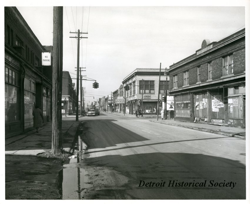
Before a freeway carried cars through downtown Detroit, Hastings Street carried a city.
It carried groceries home, children to school, patients to doctors, worshippers to church, musicians to clubs, and workers between one long day and the next. Its storefronts advertised food, medicine, records, rooms, and services. Its sidewalks held the unrecorded encounters that make a neighborhood feel like a neighborhood.
Hastings Street was more than a road through Black Bottom. It was one of the principal corridors of Black life, enterprise, faith, and culture in twentieth-century Detroit. When demolition reached the corridor and the Chrysler Freeway—now I-375—took its place, Detroit lost far more than a line of buildings.
Hastings Street had more than one Detroit chapter
The street's history did not begin with the freeway, and it did not begin with the Great Migration. From roughly 1880 to 1930, the Hastings Street area was home to working-class immigrants, including many Jewish families who had fled persecution in Eastern Europe. The Detroit Historical Museum's In the Neighborhood exhibit explores this earlier chapter through the choices, hardships, and institutions of everyday life.
Detroit's population changed dramatically as Black Southerners came north in search of industrial jobs and greater freedom. Yet racially restrictive covenants, redlining, discrimination, and a severe housing shortage narrowed where Black families could live. Black Bottom became increasingly crowded not because its residents lacked ambition, but because the housing market was structured to limit their choices.
By the mid-twentieth century, Hastings and nearby St. Antoine had become major centers of Black-owned businesses and social institutions. That transformation is part of the street's meaning: different communities built lives along the same corridor in different eras, leaving layers that should be remembered together.
Black Bottom and Paradise Valley were connected—but not identical
The names are often used interchangeably, but the geography deserves care. Black Bottom occupied Detroit's near east side, while Paradise Valley generally referred to the adjoining district north of Gratiot where many entertainment venues and businesses were concentrated. Their lives and histories overlapped, but one name should not erase the other.
Hastings Street ran through this larger world. It became a shorthand for Black Detroit because it joined homes, commerce, worship, medical care, politics, and entertainment. The Detroit Historical Society records businesses that included restaurants, grocers, physicians, and drugstores. Reverend C. L. Franklin opened an early location of New Bethel Baptist Church there. Music mattered enormously, but Hastings was never only a nightlife district.
Watch: what Detroit destroyed in Black Bottom
This History Loves Company film follows the places, people, and decisions behind the loss of Black Bottom. Watch it here, then return to the street-level details below.
Watch Detroit's Black Bottom: What They Destroyed to Build the Freeway on YouTube.
A five-second film can return a street to motion
One of the most revealing records of Hastings Street lasts only seconds. In color film dated to 1940, a girl in a pink dress waits for a car to pass and crosses a busy sidewalk. Streetcar rails, campaign signs, parked automobiles, pedestrians, and storefronts surround her.
The Detroit Historical Society identified the location through careful archival detective work: signs, city directories, streetcar tracks, business addresses, and the physical spacing of buildings. The scene was filmed on the east side of Hastings between Division and Alfred Streets. See the panorama and read how the footage was identified.
The film matters because the child is doing nothing monumental. She is crossing a street. That ordinary movement restores something a demolition map cannot: the sense that this was a lived place, not an empty tract waiting for a project.

Demolition happened in stages
It is tempting to tell the story in a single sentence: Black Bottom was destroyed to build I-375. The truth is more complicated, and the sequence matters.
Condemnation and clearance began before freeway construction. The city photographed a large portion of Black Bottom in 1949 and 1950 as part of the eminent-domain process. Much of the residential neighborhood was demolished in the early 1950s under the language of “slum clearance.” Hastings Street's business corridor remained longer, then was demolished around the turn of the 1960s as freeway construction advanced.
Residents and businesses therefore experienced not one sudden disappearance but years of disruption, removal, uncertainty, and a shrinking customer base. Describing that sequence accurately prevents the freeway from becoming the only actor in the story. Housing policy, segregation, redevelopment law, city planning, and federal highway funding all shaped what happened.
The surviving 1949–1950 property photographs carry their own painful contradiction. They were made to document buildings marked for acquisition, yet today they help descendants and researchers reconstruct the neighborhood that the acquisition erased.
Walk the vanished blocks through an archive
Black Bottom Street View maps photographs from the Detroit Public Library's Burton Historical Collection so visitors can explore streets, houses, and family histories. The project demonstrates how addresses can reconnect a family story to a physical place—even when the original street grid has been altered.
Black Bottom Archives offers another community-centered route into the neighborhood's history. Together, these resources move the story beyond a list of famous venues. They bring attention back to homes, people, and memories.
If a family document names a Hastings Street address, preserve the exact number. Search city directories, census records, church records, maps, and property photographs. A single address can reveal neighbors, occupations, congregations, businesses, and migration patterns.
The freeway story connects to Detroit's housing lines
The concentration of Black Detroiters in Black Bottom cannot be understood without the lines drawn elsewhere: restrictive covenants, discriminatory lending, redlining, and boundaries reinforced by custom and policy. Eight Mile became the city's most famous dividing line, but it was part of a much larger geography of opportunity and exclusion.
Watch Why 8 Mile Became Detroit's Most Famous Dividing Line on YouTube.
What should Detroit keep?
Remembering Hastings Street is not an argument that every building was perfect or every block prosperous. The neighborhood faced overcrowding, aging housing, poverty, and disinvestment. But those conditions do not make displacement inevitable, and they do not cancel the value residents created under severe constraints.
A complete history holds both truths: physical conditions needed investment, and the community possessed businesses, institutions, relationships, creativity, and homes worth more than the official language of clearance acknowledged.
That is why we keep names, addresses, photographs, films, and memories together. They return human scale to decisions usually described in acres, lanes, and project costs.
Continue with more Detroit history and neighborhood stories. If your family lived, worked, worshipped, or shopped near Hastings Street, share your story with History Loves Company.
For a broader challenge to the stories Detroit has been told about itself, explore Christopher Hubel's book They Lied to Us About Detroit. You can also connect with History Loves Company at The Foundry in downtown Pontiac and subscribe to Stories We Keep.
Every home has a story. Every street does, too.
Sources and further reading
- Detroit Historical Society: Black Bottom Neighborhood — neighborhood boundaries, Hastings Street, businesses, housing restrictions, and clearance.
- Detroit Historical Society: Found Footage—Black Bottom Detroit — 1940 color footage and the archival work used to identify its location.
- Detroit Historical Society: In the Neighborhood—Everyday Life on Hastings Street — Jewish immigrant life along Hastings from 1880 to 1930.
- Black Bottom Street View: About the Project — the 1949–1950 property photographs and digital mapping project.
- Black Bottom Archives — a community-centered archive of Black Bottom history and memory.