Tawas Bay · Iosco County · Lake Huron shore
Tawas Bay, a working shore shaped by sand and timber.
At Tawas Bay, the lighthouse and the land around it tell the same story from different directions. Ships needed a dependable entrance to a busy harbor, while wind and water kept extending the point that sheltered it. Follow the bay through Tawas City and East Tawas, then travel inland to the Au Sable River to connect the waterfront with lumbering, rail transportation and the remaking of a forest landscape.
The story of the place
Land and sovereignty before the mill towns
The history of this shore reaches beyond the founding dates of its municipalities. In its account of the 1819 Treaty of Saginaw, the Saginaw Chippewa Indian Tribe's Tribal Observer identifies present-day Iosco County within the treaty's cession area. Material supplied by the Ziibiwing Center describes the pressure exerted by territorial governor Lewis Cass and records Anishinaabe resistance to selling their homelands.
Sources: Saginaw Chippewa Tribal Observer: Treaty of Saginaw context
The tribe's commemoration of the treaty's bicentennial also emphasized continuing sovereignty and life on ancestral land. That perspective belongs alongside accounts of timber purchases and settlement. The later mills developed within a landscape already shaped by Indigenous communities and the consequences of treaty-making. The Ziibiwing Center's public treaty collection offers a starting point for reading that history in more depth.
Sources: Saginaw Chippewa Tribal Observer: treaty bicentennial; Ziibiwing Center: Treaty with the Chippewa, 1819
Two towns grew around different mills
Tawas City dates its founding to 1854 and the Whittemore family’s lumber enterprise. Its sheltered waterfront linked nearby forests to Lake Huron shipping. East Tawas developed separately during the 1860s around the mill of Smith, Van Valkenburg and Company, farther along the same bay. The familiar collective name “the Tawases” can obscure those distinct beginnings.
Sources: City of Tawas City: History; City of East Tawas: municipal history
Tawas City's recreation plan describes four sawmills, with docks and storage buildings occupying the shore and extending over the water. The waterfront was working space, crowded with the structures needed to process, stack and ship lumber. As nearby timber diminished, those facilities lost their purpose. Reading an old photograph beside today's shore helps recover an industrial geography that a beach view alone cannot show.
Sources: City of Tawas City: Recreation Plan
East Tawas's operators also looked beyond local forests. The city's history describes the Holland and Emery enterprise's 1891 expansion, including a sawmill, salt works, docks and hotel, supported by logs rafted across Lake Huron from Canada. The bay participated in a cross-border lumber economy.
Sources: City of East Tawas: municipal history
A lighthouse overtaken by the shore
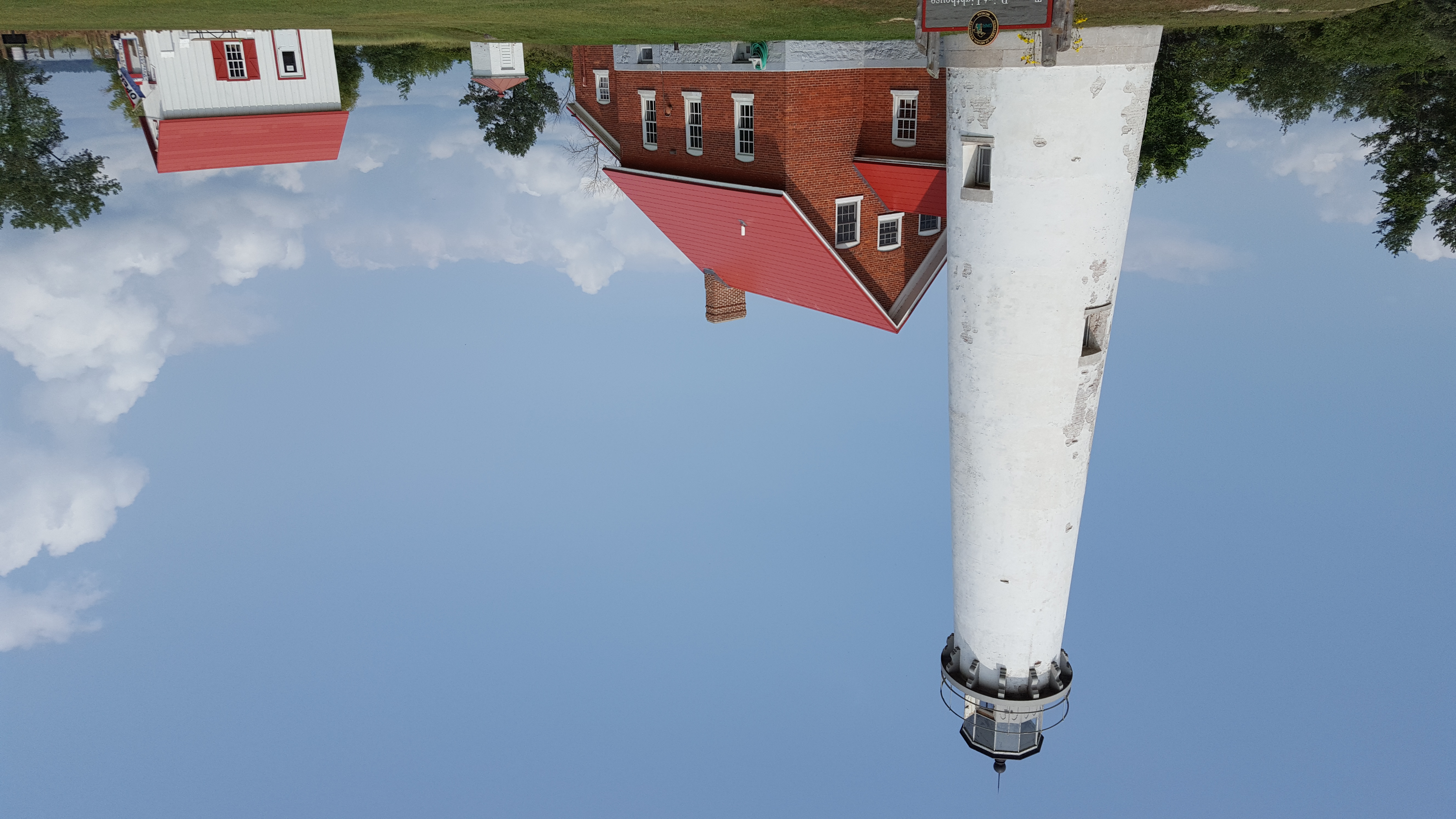
The first Tawas Point lighthouse was built in 1853, near today's state park entrance. Sand accumulated at the end of the point, extending it until the light stood more than a mile inland by the 1870s. Accretion made yesterday's useful location increasingly ineffective for ships approaching the harbor. Growing lumber and fishing traffic increased the need for a replacement.
Sources: Michigan History Center: Tawas Point Lighthouse history
The surviving lighthouse was constructed in 1876 and first lit on May 2, 1877. Its tower and attached keeper's dwelling brought navigation and household life together at the edge of the lake. The fourth-order Fresnel lens remains in the tower.
Sources: Michigan History Center: Tawas Point Lighthouse history; Michigan DNR: Restoring Tawas Point Lighthouse
The point continued growing. In 2016, the Coast Guard discontinued the tower's navigational light and installed a modern aid nearer the tip. A visit therefore crosses several shorelines in time: the position of the first light, the nineteenth-century replacement and the point as it exists today. Historic maps are especially useful here because the relationship between building and water has changed so dramatically.
Sources: Michigan History Center: Tawas Point Lighthouse history
Railways carried a changing economy
Rail transportation changed the way the bay towns connected with their hinterland. Tawas City's planning history describes commercial activity shifting toward the depot as the Detroit and Mackinac Railway carried agricultural products, including potatoes and sugar beets. Its route near the shore also influenced the town's physical layout.
Sources: City of Tawas City: Recreation Plan
Passenger excursions helped turn the coast into a destination. The Iosco County Historical Society records railway-linked development at Tawas Beach, where visitors found a dance pavilion, bowling and organized outings. Recreation grew alongside the search for livelihoods after the lumber boom. Michigan's Department of Transportation preserves another useful marker of that transition: a photograph of the Detroit and Mackinac's last passenger train at the Tawas/East Tawas depot on March 31, 1951.
Sources: Iosco County Historical Society: county history; Michigan Department of Transportation: railroad history
The Au Sable adds the workers and the river
North of the Tawases, Oscoda and Au Sable belong to a separate river-mouth story. An inland excursion along River Road connects that area with Lumberman's Monument, overlooking the Au Sable. The river carried logs toward Lake Huron sawmills; it should not be confused with the Tawas River or treated as Tawas City's waterfront.
Sources: Iosco County Historical Society: county history; USDA Forest Service: Huron Adventure Planner
Dedicated in 1932, Robert Ingersoll Aitken's bronze monument represents a surveyor, sawyer and river worker. The visitor center interprets their work through tools, logging displays and a wanigan, the floating kitchen that supplied men working along the river. These details restore some of the physical effort behind the finished boards and impressive mill totals.
Sources: USDA Forest Service: Lumberman’s Monument
The view also contains a later industrial chapter. The monument stands above Cooke Hydro's pond. Cooke began generating electricity in December 1911, so the broad water below belongs to a dammed landscape as well as a logging river.
Sources: Consumers Energy: Cooke Hydro history
A forest rebuilt after the cutting
The woodland surrounding the river has a history of its own. Forest Service accounts describe heavily logged land, unsuccessful farming on poor soils, fires and eventual public acquisition. The national forest established in 1909, later known as the Huron, became part of a long effort to manage and restore these lands. Its scenery carries the results of both extraction and conservation.
Sources: USDA Forest Service: Discover History; USDA Forest Service: forest planning history
Places and people
Begin at Tawas Point Lighthouse for the relationship between shoreline change and navigation. Check the Michigan History Center's current tour and accessibility information; reaching the tower involves 85 stairs.
Sources: Michigan History Center: Tawas Point visitor information
Continue to the Iosco County Historical Museum in East Tawas for photographs, newspapers and family-history research. Bring a particular mill, household or address to investigate, and retain the date and location attached to each image.
Sources: Iosco County Historical Society: county history
Use Lumberman's Monument for the inland part of the story. Consult Forest Service alerts before setting out, and plan the river excursion separately from the bay-town walk. Together, these places connect a changing coast with the people and industries that depended on it.
Sources & local resources
- Saginaw Chippewa Tribal Observer: Treaty of Saginaw context
- Saginaw Chippewa Tribal Observer: treaty bicentennial
- Ziibiwing Center: Treaty with the Chippewa, 1819
- City of Tawas City: History
- City of East Tawas: municipal history
- City of Tawas City: Recreation Plan
- Michigan History Center: Tawas Point Lighthouse history
- Michigan DNR: Restoring Tawas Point Lighthouse
- Iosco County Historical Society: county history
- Michigan Department of Transportation: railroad history
- USDA Forest Service: Huron Adventure Planner
- USDA Forest Service: Lumberman’s Monument
- Consumers Energy: Cooke Hydro history
- USDA Forest Service: Discover History
- USDA Forest Service: forest planning history
- Michigan History Center: Tawas Point visitor information
Research checked October 6, 2026. Consult the source institutions for current access and visitor information.