STORIES WE KEEP · SEPTEMBER 28, 2026
The Detroit River: The Waterway That Built the Motor City
Before highways and assembly lines defined Detroit, the river carried nations, freedom seekers, ferries, freight, industry—and the costs of becoming a world city.
By Christopher Hubel | September 28, 2026

Before Detroit was the Motor City, it was a river city.
The automobile eventually gave Detroit its most famous identity, but water determined where the city began. The river brought Indigenous communities, French colonists, British soldiers, American settlers, freedom seekers, shipbuilders, factory workers, immigrants, tourists, and cargoes from across the Great Lakes. It supplied industry, carried finished products, marked an international boundary, and offered generations of Detroiters a place to work, escape, celebrate, and remember.
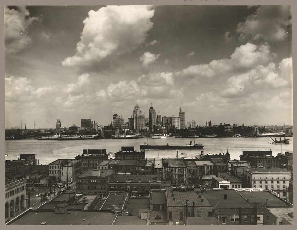
Look at Detroit from Windsor and the relationship becomes impossible to miss. The skyline faces the water. Towers rise behind docks and seawalls. Freighters pass close enough to make a city feel connected to an inland sea. Belle Isle divides the current to the east; the Ambassador Bridge and the newly opened Gordie Howe International Bridge span it to the west.
The Detroit River is not scenery beside the city's history. It is the reason the city is here.
The Detroit River is really a strait
Despite its name, the Detroit River is technically a strait: a narrow passage connecting two larger bodies of water. It runs approximately 28 miles from Lake St. Clair to Lake Erie, carrying water south through the heart of the Great Lakes system.
The French word détroit means “strait.” French explorers and traders called the waterway le détroit du lac Érié—the strait of Lake Erie. The name first described the water and then the settlement built beside it.
That geography made the passage strategically valuable. Anyone traveling between the upper and lower Great Lakes had to move through this corridor. Long before European empires claimed it, the waterway was part of Indigenous homelands, travel routes, trade networks, fisheries, and diplomatic relationships. Anishinaabe peoples—including Ojibwe, Odawa, and Potawatomi communities—and the Wyandot were among the nations whose histories are inseparable from the strait.
The river did not become important when Europeans arrived. European powers entered a place that was already known, used, named, and contested.
A fort turned the strait into an imperial border
In 1701, Antoine de la Mothe Cadillac established Fort Pontchartrain du Détroit on the north bank. France wanted to strengthen its position in the interior, control movement through the strait, develop the fur trade, and build alliances with Native nations.
Control changed after the Seven Years' War, when Britain took Detroit in 1760. The United States claimed the region after the American Revolution, but British forces did not evacuate Detroit until 1796. During the War of 1812, control shifted again: American forces surrendered Detroit in 1812 and recaptured it the following year.
Each transfer treated the river as a military route and a political line. Yet people, goods, kinship, and information continued moving across it. The international boundary created by treaties divided two countries without erasing the regional world that connected both shores.
Detroit and Windsor developed as separate cities, but the water between them also made them neighbors.
The river became a passage to freedom
For freedom seekers escaping slavery in the United States, the Detroit River could be the final dangerous distance between capture and British Canada.
Michigan was a free state after 1837, but the Fugitive Slave Act of 1850 empowered slave catchers and federal officials to seize people accused of escaping bondage. Crossing into Canada placed freedom seekers beyond the reach of United States slavery law.
Black Detroiters, abolitionists, church members, mariners, and Underground Railroad conductors helped people reach boats and crossing points. Some traveled from Detroit; others crossed farther downriver. The passage was short on a map but perilous in practice. Patrols watched the waterfront. Winter ice could help or kill. A boat operator, dockworker, or resident willing to risk punishment could make the difference between freedom and capture.
Detroit acquired the Underground Railroad code name “Midnight,” while Canada represented “Dawn.” The language captured the hope of the crossing, but it should not turn individual courage into folklore. Freedom seekers made the central decision and accepted the greatest risk. The river carried them because people on both shores chose to help.
Great Lakes commerce remade the waterfront
During the nineteenth century, the Great Lakes became an increasingly integrated transportation system. Lumber, iron ore, copper, coal, grain, stone, manufactured goods, and passengers moved through Detroit. Improved harbors, channels, canals, steam power, and larger vessels reduced travel time and expanded the scale of commerce.
Detroit developed shipyards, dry docks, warehouses, mills, foundries, railroad connections, and marine-engine works along the water. The Detroit Dry Dock Company and associated firms built and repaired vessels that served the Great Lakes. A young Henry Ford worked as an apprentice machinist in the company's orbit before his name became synonymous with automobiles.
The river helped create the industrial skills that the auto industry later used: precision machining, engine building, metalworking, patternmaking, logistics, and large-scale coordination. The Motor City did not appear from an empty field. It grew from an older transportation and manufacturing economy shaped by water.
Factories also needed the river directly. Water supported power generation, cooling, processing, waste disposal, and the movement of heavy raw materials. The Rouge River complex, Zug Island, steel mills, chemical plants, salt operations, terminals, and rail yards formed an industrial landscape extending from Detroit into River Rouge, Ecorse, Wyandotte, and other downriver communities.
Watch: how Detroit turned back toward its river
For much of the twentieth century, industry and infrastructure separated many residents from the shoreline. This History Loves Company film follows the Detroit riverfront from working waterfront and civic monuments to disinvestment, redevelopment, the RiverWalk, and the continuing question of who the water's edge is for.
Watch the History Loves Company Detroit Riverfront film on YouTube.
Ferries made the border part of daily life
Before the great bridges and tunnels, ferries connected Detroit with Windsor and nearby river communities. They carried workers, shoppers, families, horses, streetcars, and eventually automobiles. A border crossing could feel less like an international expedition than an ordinary part of metropolitan life.
Passenger steamers also turned the river into a place of leisure. Detroiters boarded elegant excursion boats for Belle Isle, Port Huron, Put-in-Bay, Tashmoo Park, Boblo Island, and other destinations. Their decks offered music, dancing, food, breeze, and relief from crowded streets and hot factories.
The S.S. Columbia and S.S. Ste. Claire became the best-remembered Boblo boats, but they belonged to a much larger excursion culture. River trips were not only transportation. They were rituals—first dates, company picnics, school outings, family reunions, and summer memories repeated across generations.

The river carried pleasure—and segregation
Public memory often softens excursion history into music, white uniforms, and summer sunshine. The boats also carried the racial rules of their time.
In 1945, the Bob-Lo Excursion Company denied passage to Sarah Elizabeth Ray, a Black woman traveling with classmates. Ray challenged the discrimination. The dispute reached the United States Supreme Court, which upheld Michigan's authority to prohibit racial discrimination by the company.
Her case linked a local day trip to a national struggle over public accommodations, interstate commerce, and civil rights. The same river that represented freedom to nineteenth-century escapees remained bordered by discriminatory practices in the twentieth century.
History rarely offers a clean symbol. Water can be a route to freedom and a site of exclusion at the same time.
Watch: the riverboat that survived Boblo
The S.S. Ste. Claire carried Detroiters to Boblo Island beginning in 1910. Its later years—including closure, deterioration, fire, and preservation efforts—show how difficult it is to save a landmark built to move.
Watch the History Loves Company S.S. Ste. Claire film on YouTube.
Bridges and tunnels changed how the region crossed
The Michigan Central Railway Tunnel opened beneath the river in 1910, creating a direct rail connection between Detroit and Windsor. The Ambassador Bridge followed in 1929, and the Detroit–Windsor Tunnel opened in 1930.
These crossings changed the geography of trade. Trains, cars, and trucks moved more reliably than ferries, even when ice or weather complicated navigation. The automobile industry organized supply chains across the border, making Detroit and southern Ontario parts of one manufacturing region.
The Gordie Howe International Bridge, opened in 2026, added a new chapter. Its scale belongs to the twenty-first century, but its purpose is centuries old: move people and goods through the strait that made this location valuable in the first place.
A modern bridge can make the river seem like an obstacle to overcome. Historically, the river was the transportation system.
Prohibition turned the border into an opportunity
When national Prohibition began in the United States in 1920, legal distilleries continued operating across the river in Canada. The narrow international boundary created ideal conditions for smuggling.
Rumrunners moved liquor by speedboat, fishing vessel, automobile, and in winter across the ice. Warehouses, docks, islands, coves, and corrupt networks supported a cross-border economy. Some shipments supplied Detroit's speakeasies; others moved onward to cities across the Midwest.
The romantic image of a fast boat outrunning patrols hides the violence and power behind the trade. Organized crime profited from prohibition, and enforcement could be inconsistent, dangerous, or compromised. Once again, geography shaped Detroit's economy—this time an illegal one.
Industry used the river as both resource and sewer
The industrial system that produced jobs, ships, steel, chemicals, and automobiles also imposed enormous environmental costs. For decades, factories and municipalities discharged waste into the river and its tributaries. Shorelines were hardened, wetlands filled, channels dredged, and habitat removed.
Oil, mercury, polychlorinated biphenyls, heavy metals, sewage, and contaminated sediment damaged fish and wildlife and made recreation unsafe in many locations. In 1987, the Detroit River was formally identified as a Great Lakes Area of Concern under the United States–Canada Great Lakes Water Quality Agreement.
Pollution was not an accidental footnote to industrial success. It was a cost shifted onto water, wildlife, workers, and shoreline communities—especially residents with the least power to prevent exposure or demand cleanup.
The river's condition improved after modern environmental laws, wastewater upgrades, industrial changes, remediation projects, and decades of advocacy. Bald eagles, lake sturgeon, lake whitefish, and other species became signs of recovery. But contaminated sediment, habitat loss, combined sewer overflows, plastics, and unequal shoreline access remain unfinished work.
Recovery made the river visible again
The establishment of the Detroit River International Wildlife Refuge in 2001 recognized that an urban and industrial river could still protect globally important habitat. The refuge now connects islands, marshes, shoals, and shoreline parcels along the lower Detroit River and western Lake Erie.
In Detroit, the RiverWalk converted stretches of former industrial and private waterfront into a public route. Parks, plazas, fishing access, restored habitat, and links between neighborhoods brought residents closer to the water.
That transformation deserves celebration and scrutiny. Public access is more than a landscaped path. It includes safe connections from neighborhoods, accessibility, transportation, affordable nearby housing, clean water, places to fish, and the ability to enjoy the river without having to purchase something.
The story of Belle Isle raises the same question on a larger island: when Detroit preserves and improves a shared landscape, who gets to use it, shape it, and feel that it still belongs to them?
The river connects every Detroit story
The Detroit River runs through stories that are often told separately. It links Indigenous history to French colonization, the Underground Railroad to the international border, shipbuilding to automobile manufacturing, Boblo memories to civil rights, industrial growth to environmental damage, and historic preservation to the future of public space.
It also points beyond Michigan. Water leaving Lake St. Clair passes Detroit on its way to Lake Erie, Niagara, Lake Ontario, the St. Lawrence River, and the Atlantic Ocean. A ship beside downtown Detroit occupies a route connecting the interior of North America to the world.
That is where Stories We Keep is going, too. Michigan history does not end at the state line. Detroit's materials, workers, products, capital, music, and ideas moved through national and global networks. Beginning with the river lets us follow those connections without losing sight of home.
If your family worked on the river, rode an excursion boat, crossed the border, fished from the shore, built ships, staffed a factory, or helped restore the water, share your story with History Loves Company. Explore more Detroit history, Michigan history, and Southeast Michigan history.
For a deeper look at the systems that made and unmade the Motor City, discover Christopher Hubel's book They Lied to Us About Detroit. Visit The Foundry by History Loves Company in downtown Pontiac, and subscribe to Stories We Keep.
Detroit grew beside the river, crossed it, worked it, polluted it, and began to repair it. To understand the city, follow the water.
Sources and further reading
- Detroit Historical Society: Belle Isle Park and the Dossin Great Lakes Museum — the river, maritime culture, and Detroit's island park.
- U.S. Fish & Wildlife Service: Detroit River International Wildlife Refuge — habitat, conservation, and the lower river's ecological importance.
- U.S. Environmental Protection Agency: Detroit River Area of Concern — environmental impairments, cleanup, and restoration.
- National Park Service: Underground Railroad — freedom-seeking networks and the broader national context.
- Windsor–Detroit Bridge Authority: Gordie Howe International Bridge — the newest international crossing and its connections.
- Library of Congress: Detroit Skyline, 1929 and Excursion Steamers, Detroit, circa 1900 — image records and reproduction information.